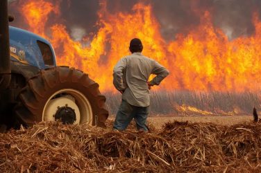

Foreigners and Brazilians who came to visit have settled permanently
in the historical city of Lençóis in Bahia. They have been the backbone of a strong
ecological movement to preserve a land that has been ravaged by forest fires, hunting, and
poisoning of rivers.
By
For the Brazilian, particularly the Nordestino, it’s impossible to speak about
the Rio São Francisco without a dose of pride and emotion. The third most important river
in Brazil, after the Amazon and Rio Paraguai, there is no river that is anthropomorphised
like the São Francisco. Those who live along its banks speak of it as a friend—hence
the affectionate nickname velho chico or chicão (Chico is short for
Francisco). At the crossroads of BR-101, BR-116 and BR-124, Feira de Santana is the main
city of Bahia’s interior, and a great cattle center. There’s not much to see here except
the Feira de Gado, the big Monday cattle market (lots of tough leather), which is great
fun, but don’t expect to buy much, and the Mercado de Arte Popular (open daily except
Sunday). The Casa do Sertão (folklore museum) and Museu Regional (Regional Museum) might
also be worth a look.
PARQUE NACIONAL DE MONTE PASCOAL
On 22 April 1500 the Portuguese, sailing under the command of Pedro Álvares Cabral,
sighted the broad, 536-meter hump of Monte Pascoal (Mt Easter), their first glimpse of the
New World. They called the land Terra de Vera Cruz (Land of the True Cross).
The park, 690 km from Salvador and 479 km from Vitória, contains a variety of
ecosystems: Atlantic rainforest, secondary forests, swamplands and shallows, mangroves,
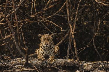
beaches and reefs. The variety of the landscape is matched by the diversity in flora and
fauna. There are several monkey species, including the endangered spider monkey, two types
of sloths, anteaters, rare porcupines, capybaras (the world’s largest rodent), deer,
jaguar, cougar and numerous species of birds.
There are plans for a visitors’ center, marked trails, picnic tables, etc, but there is
no infrastructure yet. Visitors can climb Monte Pascoal and roam through the forests at
the western/BR-101 end of the park. The coastal side is accessible by boat or on foot from
Caraiva in the north and Corumbau to the south. The north-eastern corner of the park below
Caraiva is home to a small number of Pataxó Indians—this section has been officially
closed to tourism in the past but the Pataxó don’t discourage visitors.
According to recent reports, the Pataxó have succumbed to the lucrative offers of
logging companies and allowed the park to be stripped of its valuable timber. The park
currently covers only 12,000 hectares, a figure which represents half of its original
size, and the shrinkage threatens to continue unchecked.
CUMURUXATIBA
Sandwiched between a bluff and the ocean, this two-street beach town is quiet and
slow-paced. There’s not much to it, apart from a long beach lined with amendoeira trees,
a handful of pousadas and a surprising number of good restaurants.
Boat trips to Corumbau, Caraiva and Parque Nacional de Monte Pascoal can be arranged
with Leo de Escuna on his schooner Santa Cruz de Cabrália. Contact him at Aquamar,
a barraca along the beach.
PRADO & ALCOBAÇA
These little big towns on the coast south of Cumuruxatiba don’t have much to offer
travelers—their beaches are built up and not especially pretty. If you are heading to
Cumuruxatiba to the north or Caravelas to the south, you’ll have to either pass through or
connect in one of them. Both towns have basic services and accommodation. Excursions to
Parque Nacional Marinho dos Abrolhos are best organized in Caravelas.
On a dirt track 12 km north of Prado are the semideserted beaches of Paixão and
Tororão. The dirt road continues 22 km to Cumuruxatiba. North of Cumuruxatiba, past the
ocean border of Parque Nacional de Monte Pascoal, the village of Caraiva and all the way
to Trancoso is a 60-km stretch of undeveloped coastline. Judging by the interest currently
being shown by developers, it is unlikely to stay that way. Beyond Caraiva, there are only
the miserable unpaved roads to Trancoso and Arraial d’Ajuda.
CARAVELAS
Caravelas, 74 km from Teixeira de Freitas on BR-101, is not only a gateway to Parque
Nacional Marinho dos Abrolhos; it’s also an interesting town in its own right, with a
large fishing community and good beaches nearby.
Information
Visa card cash withdrawals can be made at the Banco do Brasil on Praça Dr Imbassahi.
The IBAMA information office (Tel.: 297-1148), on Praça Dr Imbassahi, has colorful
brochures in English, with useful information about the Parque Nacional Marinho dos
Abrolhos. Abrolhos Turismo (Tel.: 297-1149), also on Praça Dr Imbassahi, is a private
travel agency, but it also acts as a kind of unofficial tourist office. English is spoken
here. There is also a small tourist information office at the rodoviária.
A reader who spent four weeks in the area as a volunteer for a whale research project
writes about Caravelas:
Caravelas is a small city with hardly any tourist facilities, which makes it a very
quiet and original place. You can hardly buy a T-shirt there, and few people speak
English. But the food in the Restaurant Jubarte (Humpback) is excellent. I recommend the
shrimp with cheese. What also makes Caravelas special is that it lies in a delta area with
mangroves and Atlantic jungle. Opposite the village is the big island of Caçumba (100 sq
km), that is surrounded by the big arms of the delta. Along the coast grows the mangrove
and inland the forest. There are about 200 families living there, who cultivate the land
for their own support. Some of their produce they sell on the mainland. There are three
species of mangrove, red, black and white, and they all grow there. What makes the
mangrove special is the extreme height of the trees (20 meters plus), probably the highest
in the world. Enormous crabs take care of oxygen in the soil—the soil is clay and
without crabs it would be too hard. In the jungle grows a variety of tropical fruits.
There are lots of different species of birds and in the swamp near the shore, crocodiles
live.
The second specialty of Caravelas is the harbor from where you can go to the protected
marine National Park of the Abrolhos Archipelago. In wintertime (end of June to October)
it is an area for Humpback whales who mate and give birth there. Their population is
increasing and is estimated now at about 400 to 700. A nature protection organization is
doing research into their social behavior and is making photos for identification.
(Bettina van Elk, The Netherlands)
Things to See & Do
To get a feel for the town’s thriving fishing industry, check out the Cooperativa
Mista dos Pescadores on Rua da Cooperativa opposite the hospital, or wander along the
riverfront to Praça dos Pescadores, where the fisherfolk hang out after coming in
from the day’s catch. For beaches, head for Praia Grauçá (eight km north of town
on a dirt track) and Pontal do Sul (across the Rio Caravelas). In addition, there
are the island beaches of Coroa da Barra (half an hour by boat) and Coroa
Vermelha (1½ hours by boat).
It’s possible to go by boat along the mangrove-lined Rio Caravelas to the next beach
town to the south, Nova Viçosa. Ask at the tourist office at the rodoviária,
Abrolhos Turismo or Abrolhos Embarcações. A snorkeling day trip to the island of Coroa
Vermelha costs $40 per person, with lunch included.
PARQUE NACIONAL MARINHO DOS ABROLHOS
Abrolhos, Brazil’s first marine park, covers part of an archipelago 80 km offshore from
Caravelas. In 1832, Charles Darwin visited here whilst voyaging with HMS Beagle. The
archipelago consists of five islands, but the only inhabited one is Santa Bárbara, which
has a lighthouse, built in 1861, and a handful of buildings. Abrolhos is being preserved
because of its coral reefs and crystal-clear waters. Underwater fishing within the park is
prohibited. The only approach is by boat, and staying on the islands is prohibited. The
Brazilian navy considers the area strategic, therefore only underwater photography is
permitted.
Unfortunately, the archipelago’s coral reefs, home to at least eight different species
of coral, have been badly affected by toxic chemicals routinely dumped by industry,
especially a pulp and paper company in southern Bahia. Dynamite fishing has depleted the
fish stocks and thereby caused rapid growth of seaweed (normally kept in check by
herbivorous fish), which is destroying the coral reefs. Experts now maintain that the
erosion caused by deforestation along the coastline is responsible for heavy levels of
sediment in the ocean, which in turn prevents sufficient light reaching underwater
organisms such as the coral.
West of Salvador
FEIRA DE SANTANA
At the crossroads of BR-101, BR-116 and BR-124, Feira de Santana is the main city of
Bahia’s interior, and a great cattle center. There’s not much to see here except the Feira
de Gado, the big Monday cattle market (lots of tough leather), which is great fun, but
don’t expect to buy much, and the Mercado de Arte Popular (open daily except Sunday). The
Casa do Sertão (folklore museum) and Museu Regional (Regional Museum) might also be worth
a look.
Festivals
Two months after Carnaval, Feira de Santana is the scene of the Micareta—a
60-year-old local version of Carnaval which brings together the best trios elétricos of
Salvador, with local blocos, samba schools and folklore groups.
The main action of the Micareta takes place on Avenida Getúlio Vargas, the city’s main
street, where 20 trios hop along for five days. The festivities begin on Thursday
with a boisterous dance and opening ceremony. The tennis and cajueiro clubs sponsor large
dances like the traditional Uma Noite no Havaí (A Night in Hawaii). For those who missed
out on Carnaval in Salvador, the Micareta could be the next best thing.
SALVADOR TO LENÇÓIS
The seven-hour bus odyssey from Salvador to Lençóis first goes through Feira de
Santana and then continues through typical sertão countryside: patches of low
scrub and cactus where scrawny cattle graze and hawks circle above. In 1995, much of the
road had been newly asphalted, but there were still odd sections where the asphalt drops
out, as if someone hadn’t done their sums properly.
The bus stops for lunch at Itaberaba where the rodoviária restaurant serves two
typical sertão dishes: carne de sol com pirão de leite (dried salted beef
with manioc and milk sauce to take the edge off the salt) and sopa de feijão (bean
soup with floating UPO—Unidentified Pigs’ Organs).
LENÇÓIS
Lençóis lies in a gorgeous, wooded mountain region—the Chapada
Diamantina—an oasis of green in the dusty sertão. You’ll find solitude, small
towns steeped in the history and superstition of the garimpeiros (prospectors), and
great hiking to peaks, waterfalls and rivers. If you want to see something different, and
have time for only one excursion into the Northeastern interior, this is the one.
The natural beauty of the region and the tranquillity of the small, colonial towns has
attracted a steady trickle of travelers for several years; some have never left. These new
residents have spearheaded an active environmental movement that successfully lobbied the
government to declare the region a national park.
History
The history of Lençóis epitomizes the story of the diamond boom and bust. After
earlier expeditions by bandeirantes proved fruitless, the first diamonds were found
in Chapada Velha in 1822. After large strikes in the Rio Mucugê in 1844, prospectors,
roughnecks and adventurers arrived from all over Brazil to seek their fortunes.
Garimpeiros began to work the mines, searching for diamonds in alluvial
deposits. They settled in makeshift tents which, from the hills above, looked like sheets
of laundry drying in the wind—hence the name of Lençóis (Portuguese for sheets).
The tents of these diamond prospectors grew into cities: Vila Velha de Palmeiras,
Andaraí, Piatã, Igatu and the most attractive of them all, the stone city of Lençóis.
Exaggerated stories of endless riches in the Diamantina mines precipitated mass
migrations, but the area was rich in dirty industrial stones, not display-quality gems.
At the height of the diamond boom, the French—who purchased diamonds and used them
to drill the Panama Canal ( 1881-89), St Gothard Tunnel, and London Underground—built
a vice consulate in Lençóis. French fashions and bon mots made their way into
town, but with the depletion of diamonds, the fall-off in French demand (and subsequently
the fail in diamond prices on the international market), the abolition of slavery, and the
newly discovered South African mines, the boom went bust at the beginning of the 20th
century.
The town’s economy has long since turned to coffee and manioc cultivation, and to
tourism. But diamonds are what the locals still dream of. The last few garimpeiros are
using powerful and destructive water pumps to wrench diamonds from the riverbeds.
Geology
According to geologists, the diamonds in Chapada Diamantina were formed millions of
years ago near present-day Namibia. Interestingly, Bahia was contiguous to Africa before
the continental drift. The diamonds were mixed with pebbles, swept into the depths of the
sea—which covered what is now inland Brazil—and imprisoned when the
conglomeration turned to stone. With the formation of Chapada Diamantina this layer of
conglomerate stone was elevated, and the forces of erosion released the trapped diamonds
which were then brought to rest in the riverbeds.
Information
The Secretaria de Turismo Lençóis has a tourist office (Tel.: 334-1121) on Avenida
Senhor dos Passos. The office can help with accommodation and has photographs of the main
attractions in the Chapada Diamantina.
The enthusiastic young guides that hang around the tourist office can be useful for day
trips—they charge about $25 per day for groups of up to four people. Jaqueline Rocha
Haj Lima in the office can recommend a guide who is familiar with the area you want to
visit.
The Prefeitura Municipal, at Praça Otaviano Alves 8, is a pretty building with b&w
photos of old Lençóis, erratic opening hours and scant information. Lampião, a local
newssheet, has some ecological information, plus the local football results and political
scandals.
Things to See
The city is pretty and easily seen on foot, although, unfortunately, most of the
buildings are closed to the public. See the old French vice consulate, a beige
19th-century building where diamond commerce was negotiated, and Casa de Afrânio
Peixoto (House & Museum of Afrânio Peixoto), with the personal effects and works
of the writer Afrânio Peixoto. Also worth a visit is Lanchonete Zacão, run by
local historian Mestre Oswaldo, which displays various mining relics and artifacts.
Festivals
The principal holidays take place in January and September. Festa de Senhor dos Passos
starts on 24 January, and culminates on 2 February with the Noite dos Garimpeiros
(Prospectors’ Night). Semana de Afrânio Peixoto, a week dedicated to the author, is held
from 11 to 18 December and coincides with the municipality’s emancipation from slavery.
Lamentação das Almas is a mystic festival held during Lent. Lençóis is also noted for
Jarê, regional variation of Candomblé.
Things to Buy
There are night stalls on Praça Horácio de Mattos selling crochet, lacework, trinkets
and bottles of colored sand collected at nearby Salão de Areias Coloridas. Funkart
Artesanato and the Mercado Municipal are other places to look for the work of local
artisans.
PARQUE NACIONAL DA CHAPADA DIAMANTINA
Many of the foreigners and Brazilians who came to visit have settled permanently in
Lençóis. They have been the backbone of a strong ecological movement which is in direct
opposition to the extractive mentality of the garimpeiros and many of the locals.
Riverbeds have been dug up, waters poisoned and game hunted for food and sport. Much of
the land has been ravaged by forest fires. The hunting and depletion of habitat has
thinned the animal population severely.
After six years of bureaucratic battles biologist Roy Funch helped convince the
government to create the Parque Nacional da Chapada Diamantina to protect the natural
beauty of the area. Signed into law in 1985, the park roughly spans the quadrangle formed
by the cities of Lençóis and Mucugê, Palmeiras and Andaraí. The park, 1520 sq km of
the Sincora range of the Diamantina plateau, has several species of monkeys, beautiful
views, clean waterfalls, rivers and streams, and an endless network of trails. Although
bromelias, velosiaceas, philodendrons and strawflowers are protected by law, these plants
have been uprooted nearly to extinction for the ornamental plant market.
The park is particularly interesting for rock hounds, who will appreciate the curious
geomorphology of the region.
Information
The park has little, if any, infrastructure for visitors. Knowledgeable guides, such as
Roy Funch and Luís Krug, can greatly enhance enjoyment of any trip into the park. Whether
you take a guide or not, you should definitely not go alone. In the descriptions of park
hikes that follow, we’ve indicated those trips which would be dangerous without a guide.
Funch, an ax-American from Arizona and now a naturalized citizen, came to Brazil 10
years ago with the Peace Corps. He pushed for the creation of the Parque Nacional da
Chapada Diamantina and has a very detailed knowledge of the region. He is currently
working on other projects, but can be contacted through the Fundação Chapada Diamantina
(Tel.: 334-1188), at Rua Pé de Ladeira 212.
Luís Krug, from São Paulo, is a guide who knows the history, geography and biology of
the area, as well as the trails. Contact Luís at Pousada Canto das Águas in Lençóis.
In Palmeiras, Claude Samuel runs trips into the park from the Pousada Candombá (Tel.:
332-2176). Claude speaks English and French, and his donkey treks have been recommended by
readers.
Day Trips Around the Park
For day trips around Lençóis, you can walk or hire a horse. For day trips further
afield you have the option of walking, hitching using the bus, or taking one of the guided
tours offered by the travel agencies and pousadas in Lençóis. The Grand Circuit
described later in this section, is best done on foot. For horse rental, contact Senhor
Dazim, who has horses available. There’s no sign on his house, so you may have to ask
around—everyone in the neighborhood knows him. You can choose from his list of horse
rides and treks, which are all accompanied. Sample prices per person are: one hour ($3);
half day ($20); whole day ($26); three days ($60). Negotiate discounts for groups of three
or more.
Bus services are infrequent and scarce, particularly to the remote parts of the park.
Day Trips Around Lençóis
Rio Lençóis
You can start a pleasant hike along the Rio Lençóis by following a trail southwest
from the rodoviária (and continuing through the Parque Municipal da Muritiba,
upstream to Cachoeira Serrano (a series of rapids) and Salão de Areias Coloridas
(literally Room of Colored Sands), where artisans gather their matéria prima for
bottled sand paintings. If you continue up the river, you’ll see Cachoeirinha waterfall on
a tributary to your left, and after passing Poço Paraíso waterhole, you’ll see Cachoeira
da Primavera waterfall on another tributary on your left. From the rodoviária to
here takes around 1½ hours on foot.
Ribeirão do Meio & Cachoeira do Sossego
This is another relaxing hike (45 minutes) that can be made to Ribeirão do Meio. Take
the road uphill from Camping Lumiar, ignoring the left turning you’ll see after about 100
meters, and continue until the road ends at a white house. After continuing for a short
distance, take the left fork of a trail which descends and crosses a stream. Keep
following the track until you reach a ridge overlooking Rio Ribeirão, a tributary of Rio
São José.
At the foot of the ridge, you’ll find Ribeirão do Meio, a series of swimming holes
with a natural waterslide (bring old clothes or borrow a burlap sack). It is very
important not to walk up the slide: several bathers who have done so have met with nasty
accidents. Instead, swim across to the far side of the pool and climb the dry rocks at the
side of the slide before launching off.
Upstream from Ribeirão do Meio, a trail leads to Cachoeira do Sossego waterfall. The
hike involves a great deal of stone-hopping along the riverbed. On no account should you
attempt this trail during high water or rain: the river stones are covered with lichen
which becomes impossibly slippery. To walk there and back to Lençóis takes around five
hours.
Gruta do Lapão
This is probably the largest sandstone cave in South America. Access is tricky and it’s
necessary to take a competent guide—ask at the tourist office. The walk takes around
four hours.
Day Trips Further Afield
Lapa Doce, Gruta da Pratinha & Gruta Azul
These three sights are best visited by car—the guided day trips offered by travel
agents and other operators in Lençóis usually take in all of these sights. Lapa Doce (70
km from Lençóis, then a 25-minute hike to the entrance) is a huge cave formed by a
subterranean river. Access to the cave is via an immense sinkhole; inside there’s an
impressive assortment of cave decorations which prompt erotic comparisons. Admission costs
$0.50.
About 12 km from this cave are Gruta da Pratinha and Gruta Azul, two more caves of
lesser interest, which have been spoilt by pollution and vandalism.
Rio Mucugêzinho
This river, 25 km from Lençóis, is a super day trip. Take the 8 am Palmeiras/Seabra
bus, and ask the driver to let you off at Barraca do Pelé—the bus passes this place
again at around 4 pm on its return trip to Lençóis. From Barraca do Pelé, pick your way
about two km downstream to Poço do Diabo (Devil’s Well), a swimming hole with a 30-meter
waterfall. Further upstream, you’ll find Rita and Marco, who have set up house in a cave
and run a snack bar outside.
Morro do Pai Inácio & Barro Branco
Morro do Pai Inácio (1120 meters) is the most prominent peak in the immediate area.
It’s 27 km from Lençóis and easily accessible from the highway. An easy but steep trail
takes you to the summit (200 meters above the highway) for a beautiful view.
Hikers may want to take the trail along Barro Branco between Lençóis and Morro do Pai
Inácio—allow four or five hours one way for the hike.
Palmeiras, Capão & Cachoeira da Fumaça
Palmeiras, 56 km from Lençóis, is a drowsy little town with a slow, slow pace and a
scenic riverside position. The streets are lined with colorful houses. There is one pousada
in the town and a couple of cheap pensões.
The hamlet of Capão is 20 km from Palmeiras by road From here, there’s a six-km trail
(two hours on foot) to the top of Cachoeira da Fumaça, also known as the Glass waterfall,
after missionary George Glass, which plummets 420 meters—the longest waterfall in
Brazil. Although marked on the map, the route to the bottom of the waterfall is very
difficult, and isn’t recommended.
The Grand Circuit
The grand circuit of the park covers around 100 km and is best done on foot in a
clockwise direction. It takes about five days, but you should allow eight days if you
include highly recommended side trips, such as Igatu and Cachoeira da Fumaça.
Lençóis to Andaraí
For this section you should allow two days. On the first night, camp at a site near Rio
Roncador. On the way, you pass Marimbus, a microregion with characteristics similar to the
Pantanal. In Andaraí, either camp or stay at the basic Pensão Bastos.
Poço Encantado & Igatu
These side trips are highly recommended. Poço Encantado, 56 km from Andaraí, is an
underground lake which is clear blue and stunningly beautiful. You’ll need a car to get
there; hitching is difficult because there is very little traffic.
Igatu, 12 km from Andaraí, is a small community with an intriguing set of ruins
(highly recommended). Either walk or drive to Igatu.
Andaraí to Vale do Pati & Ruinha
This section takes a day, but you should allow an extra day to potter around the
valley: for example, doing a side trip to Cachoeirão (a delightful waterfall) or enjoying
the atmosphere in the tiny ghost settlement of Ruinha.
Vale do Pati to Capão
This section, which crosses the beautiful plains region of Gerais do Vieira, is best
covered in two comfortable days, although it’s possible to do it in one very long day.
The tiny settlement of Capão serves as a base for the highly recommended hike to
Cachoeira da Fumaça. In Capão, you can camp or stay at the Pousada Candombá for
$2.50 per person, with breakfast an additional $1.50.
Capão to Lençóis
You’ll need a full day to hike this section. From Capão, follow the road through
Caeté Açu, and when you reach the `bar’, take the track to the right. Follow the main
track east, crossing the river several times, before veering off to reach Lençóis. There
are a couple of campsites along the track on the section between the `bar’ and Lençóis.
RIO SÀO FRANCISCO
For the Brazilian, particularly the Nordestino, it’s impossible to speak about
the Rio São Francisco without a dose of pride and emotion. The third most important river
in Brazil, after the Amazon and Rio Paraguai, there is no river that is anthropomorphised
like the São Francisco. Those who live along its banks speak of it as a friend—hence
the affectionate nickname velho chico or chicão (Chico is short for
Francisco).
The geographical situation of the São Francisco gave it a prominence in the colonial
history of Brazil that surpassed the Amazon. Born in the Serra da Canastra, 1500 meters
high in Minas Gerais, the Rio São Francisco descends from south to north, crossing the
greater part of the Northeast sertão, and completing its 3160-km journey in the
Atlantic Ocean after slicing through the states of Minas Gerais and Bahia, and delineating
the borders of the states of Bahia, Pernambuco, Sergipe and Alagoas.
For three centuries the São Francisco, also called the `river of national unity’,
represented the only connection between the small towns at the extremes of the sertão and
the coast. `Discovered’ in the 17th century, the river was the best of the few routes
available to penetrate the semi-arid Northeastern interior. Thus the frontier grew along
the margins of the river. The economy of these settlements was based on cattle, to provide
desperately needed food for the gold miners in Minas Gerais in the 18th century and,
later, to feed workers in the cacao plantations in southern Bahia.
Although the inhabitants of the region were often separated by enormous distances,
cattle ranching proved a common bond and produced a culture which can be seen today in the
region’s folklore, music and art.
The history of this area is legendary in Brazil: the tough vaqueiros who drove
the cattle; the commerce in salt (to fatten the cows); the cultivation of rice; the rise
in banditry; the battles between the big landowners; and the religious fanaticism of
Canudos.
The slow waters of the São Francisco have been so vital to Brazil because in a region
with devastating periodic droughts, the river provides one of the only guaranteed sources
of water. The people who live there know this, and thus, over the centuries, they have
created hundreds of stories, fairy tales and myths about the river.
One example is the bicho da água (beast of the water). It is part animal and
part man that walks on the bottom of the river and snores. The crew on the riverboats
throw tobacco to the bicho da água for protection.
The river’s width varies from two handspans at its source in the Serra da Canastra, an
empty, uninhabitable region where nothing grows, to 40 km at the Lagoa do Sobradinho, the
biggest artificial lake in the world. As a result, Nordestinos believe that São
Francisco is a gift of God to the people of the sertão to recompense all their
suffering in the drought-plagued land.
River Travel
People have always traveled by the São Francisco. In the beginning there were
sailboats and rowboats, then came the motorboats, which became famous because of the
personalities of the barqueiros who drove the boats and put carrancas on the
front of them. Carrancas are wooden sculptures that represent an animal-like
face—part dog, part wolf—with big teeth and open mouth. These sculptures are now
popular as folk art, and are sold in Salvador and at fairs along the river.
Today, with the river cities linked by roads, river traffic has decreased drastically,
but it shouldn’t prove too hard to find boats for short trips on local market days
(usually Saturday).
Bom Jesus da Lapa, on the São Francisco in the interior of Bahia, is the site of one
of the most important religious festivals and processions in the sertão. The
festival is held on 6 August.
It may be possible to hire a local boat from Juazeiro, on the Pernambuco-Bahia border,
to Xique-Xique, 200 km downstream in Bahia.
A reader wrote to us with the following assessment of river travel along the Rio São
Francisco:
The river appears dead as a means of commercial travel, and only a small amount of
transport by local narrow boat continues between the villages. The river has become
sluggish as a result of construction of a hydroelectric plant on the seaward side of Lagoa
do Sobradinho, and silting is so severe in some places that the shallow-draught local
boats touch bottom.
Xique-Xique, at the southern end of Lagoa do Sobradinho, appears to have a mainly
school-age population, most of whom are learning English and are keen to use it. A couple
of islands close to the town have been declared a reserve for the protection of anteaters,
which are said to be the only ones in the area.
Excerpts from Brazil – A Travel Survival Kit, 3rd edition, by
Andrew Draffen, Chris McAsey, Leonardo Pinheiro, and Robyn Jones. For more
information call Lonely Planet: (800) 275-8555. Copyright 1996 Lonely Planet Publications.
Used by permission.
Buy it at
Amazon.com
Lonely Planet
Brazil – A Travel Survival Kit
by Andrew Draffen, Chris McAsey,
Leonardo Pinheiro, Robyn Jones,
704 pp
Send your
comments to
Brazzil