
Brazil topped the list of the world’s most important Places to Watch for deforestation, in a new initiative that uses near real-time satellite to highlight forest loss.
Satellites detected more than 50,000 hectares of tree cover loss – equivalent to more than 60,000 soccer fields – since October in the Kayapó Indigenous Territory in the Brazilian Amazon, Global Forest Watch (GFW), a U.S.-based charity said.
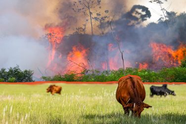
“September saw the most fires ever recorded in a single month, and 2017 now is on track to break the record for most fires in a single year,” GFW said.
“Though there is a drought happening, almost all of the fires are human-caused, likely to clear forest for agriculture.”
Forest fires in Brazil and Indonesia contributed to a record loss in global tree cover in 2016, equivalent to the size of New Zealand, that could accelerate deforestation blamed for climate change, GFW said.
Places to Watch provides detailed information on when, where and why forests are being cleared on a weekly basis.
“After identifying these hotspots our team reaches out to partners on the ground to find further details about what’s taking place,” Katie Fletcher, a spokeswoman for GFW said.
The initiative will help to monitor forests and protect land rights amid budget cuts to institutions in Brazil in charge of protecting indigenous peoples, said Barbara Zimmerman, who heads the International Conservation Fund of Canada’s work in Kayapó.
Around 8,000 Kayapó live on more than 11 million hectares of legally protected land, one of the few remaining patches of undisturbed forests on the edge of the Amazon, GFW said.
“The Kayapós and other indigenous groups are really on their own,” said Zimmerman of ICF, which helped GWF with its research.
“The government is not present …. There is no law.”
Officials from Brazil’s indigenous affairs agency, Funai, and the environmental protection agency, Ibama, were not immediately available for comment.
GFW launched a mobile app in September which directs indigenous people, forest managers and law enforcement officials to remote areas where forests are being cleared, so they can capture photos and enter data about deforestation.
The other top Places to Watch this week are the Democratic Republic of Congo, Indonesia and Papua New Guinea.
This article was produced by the Thomson Reuters Foundation. Visit them at http://www.thisisplace.org


